Hot 5 Unusual Churches


Siegerland, Germany

When the only neighbouring attraction is a service station littered with truckies and fast food restaurants it doesn’t take much to stand out. Yet the Autobahn Church Siegerland goes above and beyond to demand the attention of every passing motorist, with a curious modern design best described as a large, white replica of Batman’s headpiece. Its interior is equally bewitching, with a timber honeycomb dome and simple, box-like chairs. Situated on the busy A45 in Wilnsdorf, an hour’s drive west of Cologne, this chapel offers travellers space to reflect and worship or just relax beside the frantic pace of the motorway. Although this religious edifice is not the only one of its kind (there are some 40 other autobahn churches in Germany), Siegerland is arguably one of the country’s most original. Ducking across the highway for a quick roadside coffee post-sermon will have you revived and ready to hit the open road once again.

Distant benediction
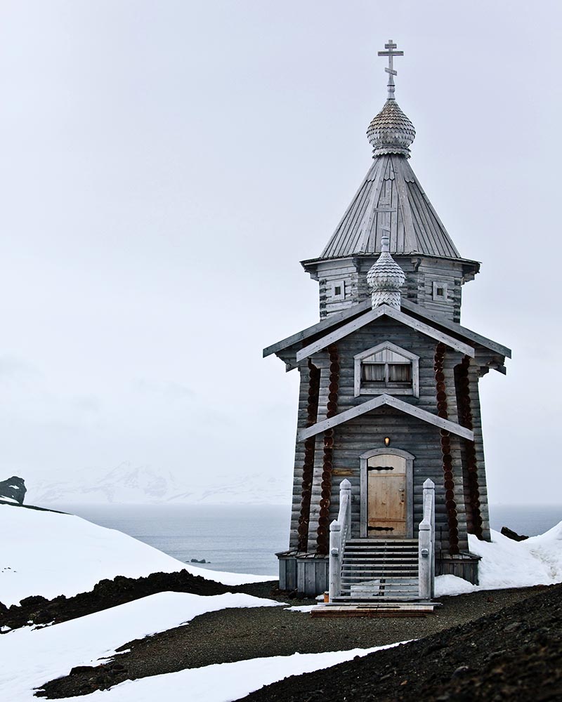
King George Island, Antarctica

A crowdfunded Russian Orthodox Church perched at the top of a craggy hill, on an island at the end of the world. No your eyes do not deceive you – this tiny clapboard structure, shackled to the coast, can weather polar winters, and has done so since its consecration in 2004. Situated on one of the most isolated and barren stretches of land on the planet, Trinity Church is manned year-round by two priests who hail from the Trinity Lavra of St Sergius, which is said to be the most important monastery in all of Russia. Aside from delivering mass to the resident population (which fluctuates between 100 denizens in winter and 500 in summer) the clergymen stationed here are also responsible for the occasional baptism and even wedding. The surreal surrounds of this lone sub-zero church might just offer churchgoers a spiritual awakening.

Sacred bones
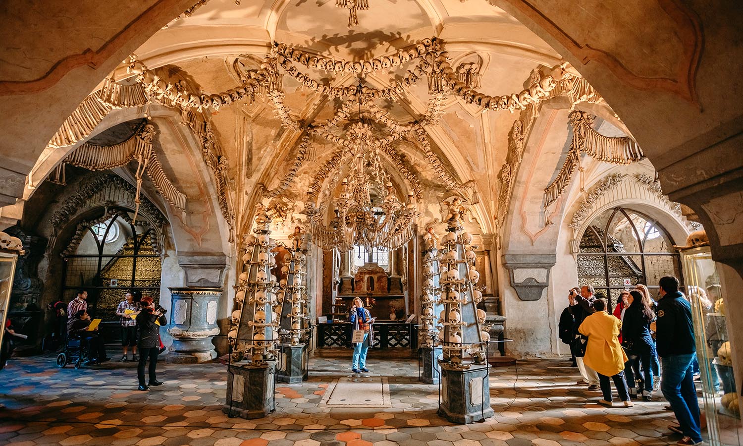
Kutná Hora, Czech Republic

When life gives you human remains, make art. That appears to be the principle woodcarver František Rint followed when he revamped the Sedlec Ossuary in the 1870s. His interior design arsenal? Tens of thousands of bones. And the result? A spellbindingly macabre interior festooned with skulls, femurs and tibias. Even the imposing candelabras, coat of arms, chalices and bunting are fashioned out of skeletons from the plague of 1318. Located in the suburbs of the UNESCO World Heritage-listed city of Kutná Hora, about an hour’s drive east of Prague, this small Roman Catholic chapel was originally built in 1400. For anyone touring Europe and suffering from a serious case of church fatigue, this kooky house of worship will no doubt offer some respite.

Natural appeal
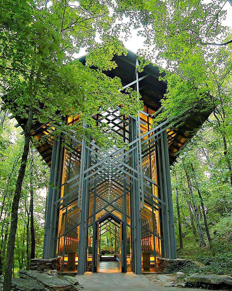
Eureka Springs, Arkansas

Almost abandoned due to lack of funds, the glorious 15-metre tall Thorncrown Chapel is a feat of both persistence and faith. Back in the 70s, retired schoolteacher Jim Reed noticed tourists frequently roamed through his property to scope out the beauty of the Ozark Mountains. Rather than fence them out, he teamed up with renowned architect E. Fay Jones to develop Thorncrown, a place of worship immersed in a forest of oaks, pines and maples. As soon as it opened in 1980 the structure began raking in accolades, including the Design of the Year Award bestowed by the American Institute of Architects in 1981. Constructed with 425 windows holding 152 metres of glass and a roof soaring to the heavens, the building blends in with its surroundings so well that you’ll forget you’re inside a church. Settle into a pew atop the stone floor and worship at the altar of Mother Nature.
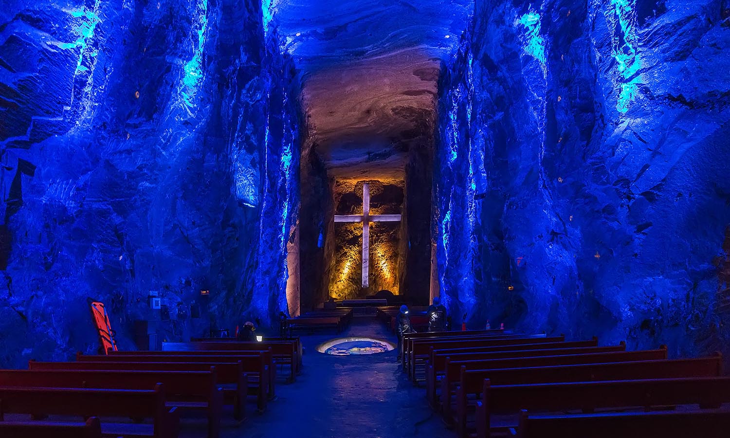
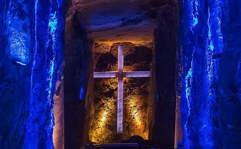
Deep devotion
Zipaquirá, Colombia

Who would’ve thought that Berlin warehouse rave-style lighting and religious symbology could intertwine so harmoniously? Colombian Catholics appear to have stumbled upon this exact enlightened conclusion 25 years ago, while transforming an abandoned salt mine into an illuminating site of supplication. The glowing lights add more than a dash of the 90s to the cavernous space that featured a (rather more modest) holy site even in the 30s, when miners would pray before a day of hard labour. Now you no longer need to don a hard hat – or fear for your life – to journey to its depths, 180 metres underground. Instead you can simply marvel at its 14 small chapels and carved salt sculptures, such as a five-metre tall cross, all dedicated to Our Lady of Rosary, the patron saint of miners. Should you ignore basic hygiene and sneak a quick lick of the cathedral’s walls, you’ll taste 250-million-year-old salt. And if all that sodium’s left you thirsty there’s even Colombian coffee on offer in an adjoining subterranean cafe.

At Its Peak

The traverse of the Grand High Tops in Warrumbungle National Park has long been one of the best day hikes in New South Wales. The craggy remnants of this 17-million-year-old shield volcano command respect, awe and a lot of leg work.

The climb to overlook the jagged edges of Breadknife will leave you hungry for Vegemite toast, and begin to gnaw at your appetite for adventure, but will it satisfy? Perhaps not. The Warrumbungles warrant more than a mere day trip. It’s likely you’ve driven hours to be here – surely you don’t want to rush beneath the granite tors and whiz past every vista as you sneak a peek at your watch. This is one of the most scenic tracks in the state. Best to pack a tent.

With multiple bush-camp options along the way, plus the chance to catch sunrise from the summit of Bluff Mountain, an overnight hike is the only way to trek the Grand High Tops trail. Geology’s been at work for millions of years here – you can spare an extra day.

Eyes on the Trail

The first few kilometres are a tease. Wandering through the shade of the surrounding forest, with only fleeting views of the erupting tors overhead and streams trickling and twisting below the elevated path, this is by far the easiest section of the hike. Savour it while it lasts.

As you begin to ascend, the dirt trail turns to pavers and the canopy overhead starts to dissipate. With eyes to the ground and one foot in front of the other, climbing the pavers is a toil, especially when carrying all your gear.
As you gain altitude, Belougery Spire begins to rear its head above the trees. Soon, staircases replace pavers and you realise you’re ascending straight up the guts of the grandest of high tops. Breadknife is on your right, Belougery Spire to the left. With each step up, another inch of them is revealed.

You’ll land right by the base of the Breadknife, so scramble up to its perfectly etched teeth to peer through to the vistas on the other side.

Round the corner and clamber up onto a rocky outcrop positioned between the Breadknife and Belougery Spire for a lunchtime view you’ll never forget. Find yourself a flat spot between the sloping rock to carefully balance your pack and aching body a while.

There’s one last ascent to the ridgeline, with a side of bouldering thrown in, and you’re delivered a panorama of the entire park – and the first sighting of Crater Bluff, a gobsmacking monolith with a plummeting sheer wall.

Take a breather, sit back and soak in the surroundings. This is what you came here for, after all. Crunch on an apple, but don’t let the sun punch you too hard – there’s no shade to hide in up here.

Forge Your Own Path

Although the Grand High Tops walk is a loop, few people follow the path the entire way around, choosing instead to retrace their steps back to the finish line. As the day trippers turn back to descend the stairs they just climbed, you’ll head down the opposite side of the ridge along fresh terrain.

Don’t miss catching the opposing face of Breadknife before you slip back under the forest canopy and out of the sun. The crowds who pour in to see the Grand High Tops vistas are gone and you’re left with the twittering of superb fairy wrens and the satisfying thud of your own footsteps.

After a few kilometres of forest wandering, you’ll arrive at your home for the night, Dows campgrounds. This small clearing at the base of Bluff Mountain teems with native birdlife. Although small, it’s a serene spot with firepits and a narrow creek.

The last stragglers pass the campground well before dark, and the distinct lack of human noise cements your immersion into the wilderness. This remote campground has only three pitches, so if you’re sharing the space it’s going to be tight. As you find a flat patch of green to raise your tent, gaze up through the twisting gums at Bluff Mountain. That’s your morning mission.

If you can will yourself to stay up late enough, wander back onto the path where the trees are more sparse and drink in the Milky Way. Warrumbungle National Park is Australia’s only Dark Sky Park, where starry night skies are exceptionally bright and there’s a concerted effort to protect it. Nightly stargazing is mandatory here.

Carpe Diem up Bluff Mountain

Today, you need to be up before the birds. While it’s still dark, tighten your laces and grab your drink bottle. Even better, grab some brekkie and kit to brew yourself a cuppa. The hike to the peak of Bluff Mountain is only 1.3 kilometres, but as you’re already at the base of this beauty, it’s all uphill from here.

The freedom from your pack will make it feel like you’re flying. Hike up giant sandstone steps and count the colours of the native orchids sprouting around your feet. Zig-zag your way up the mountain as the darkness begins to lift.

As you emerge onto the rocky ridgeline, the trees will fall away and the sun will send its first beams across the path you forged the day before. Bluff Mountain gives you a whole new perspective of the surrounding farmlands that hide in shadow, waiting for the sun to thaw them out.

Sit a while. You’re in no hurry. Make yourself a coffee and watch for wedge-tailed eagles circling the skies. When you’re ready, saunter back down to camp.

From Dows campgrounds, there’s six kilometres of the loop to complete with no elevation left to gain. Admire wax-lip orchids and paper daisies before turning back to see Bluff Mountain in its entirety, knowing that, not long ago, you sat atop its epic crown. The downhill track here is a bit rocky and unstable, which can be tricky to navigate when you’re carrying an almost full pack.

Once back on flat ground, breeze your way through the tall grasses that line the final stretch of trail and rock hop across the streams. It won’t be long before you’re back in familiar territory, with the last kilometre of the hike the same as the first. Proudly stride into the car park, as the day hikers begin their journey up the Grand High Tops trail, knowing you’ve just completed an epic 17-kilometre hike.

We Are Explorers is an online magazine featuring Aussie adventures and backed by a community of explorers. Head to weareexplorers.co to start planning
your next wild adventure.

High Point
Bay of Islands, New Zealand

This is a place awash with restful, contemplative destinations. Throughout the 144 islands and many more beaches that make up the Bay of Islands, you can take your pick of places to put up your feet and admire easy-on-the-eye views. But few pack in as much to appreciate and contemplate as Matauri Bay. Off the main road (technically State Highway 10), you drive out through farmland to reach the perfect curves of the beach where tropical-blue water laps the coast and, occasionally, an idyllic wave rolls in for the surfers.

A few kilometres offshore are the Cavallis, a cluster of islands that beckons with more white-sand beaches. Between the Cavalli Islands and Matauri Bay rests the Rainbow Warrior, the Greenpeace ship bombed by the French Government in Auckland Harbour in 1985. The attack, which killed Greenpeace photographer Fernando Pereira, put paid to the Warrior sailing to the island of Mururoa in French Polynesia to protest French nuclear testing there. As a bombastic affront, New Zealand had never experienced anything like it.

Ngati Kura, the tangata whenua (people) of Matauri Bay, who have a settlement at one end of the beach, generously provided the final resting place for the Warrior and it was sunk offshore in 1987. It has since become a popular dive spot. The best place to appreciate all this (and then some) is at the lookout above the bay – the short climb to the top starts at the path just beyond the campsite. In addition to the views, one of the prizes at the top of the hill is the sculpture by New Zealand artist Chris Booth. The artwork was unveiled in 1990, stands more than 10 metres tall and incorporates a six-tonne central basalt column and the Warrior’s bronze propeller. The sculpture, which curves like a rainbow and casts dramatic shadows throughout the day, was funded by Ngati Kura and New Zealand China Clays, which harvests the local, highly prized halloysite clay for export.

From the lookout cast your eye out to the Tasman and your imagination back to 1814, when the Reverend Samuel Marsden sailed across from Sydney and made landfall at Matauri Bay. Marsden was so taken by his welcome from local chief Hongi Hika, along with the ensuing haka and feast, that he eventually left his mission in Parramatta to establish a new one in the Bay of Islands. – Jo Bates.

Branching Out
Okinawa, Japan

In the north of tropical Okinawa, just outside Nago City, Maha Kikugawa has been slowly building a sustainable retreat from scratch. Set in dense forest beside the Genka River, Treeful Treehouse EcoResort is a series of three luxurious and utterly breathtaking residences with beautiful views in every direction. But Maha hasn’t only gone all in impressing guests; she’s also undertaken regeneration of the land and waterways around the property to create an outpost of tranquillity on the island. The resort is due to open in the northern hemisphere spring, and we’re pretty sure there’ll be a rush on bookings.

treeful.net

Live the High Life
New South Wales, Australia

Orange one day, a working sheep station deep in the dusty outback the next. Oh, and don’t forget to add a pit stop in Kangaroo Valley. If this sounds like one impossible itinerary, prepare to have your mind blown. It’s all achievable thanks to the team at Crooked Compass By Air, who organise personally tailored jaunts that are made all the more exclusive by the use of private planes. Yep, you’ll be jetsetting to remote wineries and secluded homesteads in the fixed-wing aircraft of your choice on the Winelands, Station Stays and the Wild Coast tour. Showcasing the best of regional New South Wales, the trip also includes a scenic flyover of the Blue Mountains, a two-night stay at the isolated Corynnia Station (pictured), incredible foodie experiences and a relaxing stopover at a property set in the rolling hills of the South Coast. Best of all, absolutely everything can be customised to your style, pace and budget.

crookedcompassbyair.com

Arctic Bliss
Svalbard, Norway

Its real name is Juva Cabin, but lots of people refer to it as The Jewel. And it’s not hard to see why. Set in the wilderness and surrounded by snow-covered peaks, it will be a sight for sore eyes after you’ve spent all day on a snowmobile zipping around mountain ranges and fjords, all the while keeping watch for polar bears. (Don’t fret, because your Hurtigruten guide is an expert at seeing them against the white backdrop.) The cabin is cosy, with a living room, kitchen and three bedrooms, but it’s what’s outside that really captures the imagination. There’s a tube-formed sauna (pictured) with a circular window at one end so you can stay tuned for the appearance of the northern lights.

hurtigrutensvalbard.com

Peace Out in Paradise
Pumpkin Island, Queensland, Australia

While private islands are often in the realm of billionaires and A-list celebs, there’s a tiny landmass 14 kilometres off the coast of Yeppoon that offers a taste of barefoot luxury to us mere mortals. Pumpkin Island, hidden away in the southern Great Barrier Reef, is a blissfully tranquil sanctuary that’s home to just seven eco-friendly and self-contained beach bungalows. Arrival is by boat transfer only, and you’ll need to bring everything required for the duration of your stay – we’re talking clothes, food and drinks. There is, however, a licensed bar on the island for a cheeky sundowner. SUP boards, snorkel gear and glass-bottom kayaks are available for use when sunning yourself on the empty white-sand beach becomes too much, otherwise scuba diving and fishing tours can be arranged. With a maximum of just 34 people permitted on Pumpkin at one time, you can embrace full relaxo mode safe in the knowledge every other guest is doing the same.

pumpkinisland.com.au

Lace Up Your Boots
Mount Barney, Queensland, Australia

Keen to explore Queensland’s Scenic Rim area? Well, there’s only one way to do it: by hiking Mount Barney. Now, first things first – to reach the summit (at 1,354 metres this is the second-highest peak in the region) you’re going to need to be match fit, because this is one tough climb. If you’re staying at Mount Barney Lodge, a sprawling property offering a range of accommodation options, there are experienced guides available who will lead you on the full-day hike. Not only will they share info on the plants and animals you’ll see along the way, but they’ll also ensure you don’t veer off the track and fall down a ravine. Don’t scoff – people have died attempting to reach the top. Before we scare you out of it though, know the rewards are plenty. The natural landscape is absolutely breathtaking, scrambling up and over boulders is really good fun, and the views will make you gasp out loud.

mtbarneylodge.com.au

Water Beats
Gaua, Vanuatu

It toots its horn as the second-most populous spot in the Torba Province, which may not sound appealing if you’re looking to leave civilisation behind. Then you realise the population of Gaua is just 2,500 people and you relax again. By far the best reason to visit here is to climb Mount Garet, the island’s volcanic peak, from whose dizzy heights you can stare down into Lake Letas, situated in the crater. It’s not an easy climb, but Victor, the local guide, will go at a pace to suit – it’ll take between one and three days – stopping at villages along the way. If trekking isn’t your cup of kava, hopefully you’ll be able to catch some water music, a style of performance that goes back centuries and, through rhythmic splashing of the surface and singing, is the women’s way of telling their stories.

vanuatu.travel

Highway Patrol
Mount Dare, Northern Territory, Australia

The thing about roads in the outback is they’re often fairly, well, rudimentary. That’s why you’re going to need a solid 4WD and a bit of planning to take on Binns Track. You can’t really call it a road trip because this 10-day epic adventure follows what is, as the name suggests, a 2,230-kilometre track. The starting point is Mount Dare, on the South Australian border, then the road follows the edge of the Simpson Desert to Alice Springs through old gold towns, past immense cattle stations and into the Top End before finally finishing at Timber Creek. Take your time because there’s heaps to do along the way, including visiting rock art sites and taking in the majesty of Karlu Karlu (Devils Marbles). If you’re wondering, Bill Binns was a ranger with NT Parks and Wildlife and spent much of his adult life showing visitors around Central Australia.

northernterritory.com

Dog Days
Yukon, Canada

Get ready for the perfect storm of fun and freedom. At Sky High Wilderness Ranch, there’s the chance to team up with man’s best friend. Well, a whole bunch of them, really. During the northern hemisphere winter, get hands-on during one of the property’s multiday adventures. You’ll learn all about your team of dogs – handling, harnessing, as well as general care – then start mushing as you come to grips with driving the sled. The first few days are spent getting used to it and the strain it puts on your body, with nights spent at the lodge. Then it’s out into the snow. You’ll explore ranges and lakes and watch for moose, before setting up camp for the night when the temperature can fall to -40ºC. Each trip lasts for between seven and 14 days, so you’re going to have to ask yourself: are you tough enough?

skyhighwilderness.com

Track Star
Hinchinbrook Island, Queensland, Australia

This is a great test of your mettle and ability to plan ahead. Hinchinbrook Island’s Thorsborne Trail is (at least) a four-day foray that winds up mountains, through rainforests, along beaches and past waterfalls. Chances are you won’t see anyone else here either, because just 40 people are permitted to camp on the island at any one time.

There’s no doubt about it, Hinchinbrook is a beauty. Located just eight kilometres off the coast, about halfway between Townsville and Cairns, it’s part of the Great Barrier Reef Marine Park ensuring nature lovers won’t be disappointed. Dugongs swim in the shallow waters, turtles can be seen on the beach along from Ramsay Bay, mangroves play host to a vast array of marine animals, and brilliantly coloured butterflies often swoop across the trail. This is also croc country, so care needs to be taken around beaches and creeks.

On paper it looks simple enough: 32 kilometres along the island’s east coast, completed over a number of days, with nights spent at campgrounds along the way. Sure, you have to carry everything except a week’s worth of water – there are a number of places to refill on the trail – but it’s only for a few days. True, it doesn’t seem that far, but parts of the hike are very challenging. Clambering over boulders, crossing creeks and trudging through swamps is all part of the journey. You’ll need to be in good shape to take it on.

The payoffs, however, are enormous. Take the end of day two as an example. This is when you’ll reach camp at our cover star, Zoe Falls. Being up high, this is a perfectly safe spot to take a dip. Your only companions will be the yabbies and jungle perch in the water. In fact, we’d venture to say this is one of the most picturesque swimming holes anywhere in the country. As your aching body cools off in the pool, stare out over the forest and ocean. The only thing better is waking up early the next morning and doing it all again while watching the sun rise.

parks.des.qld.gov.au

Mountain Highs
Falls Creek, Victoria, Australia

Most of us associate this part of Victoria with skiing, but summers in the High Country are set to 10 on the spectacular scale. (The spectacular scale isn’t really a thing – we just made it up.) Get away from the villages and immerse yourself in nature thanks to Diana Lodge’s alpine glamping experience. Perfectly suited to those who want to do some serious hiking or give their mountain bikes a workout, it’s equally appropriate for those who simply want to read, play board games or sit out in the dark and watch the stars. Everything’s provided, including tent set-up, bedding, a full meal hamper, portable phone charger and drop-off of your gear if you want to get there on foot or by bike.

dianalodge.com

Drive Through Art
Merredin, Western Australia, Australia

For those of us who don’t mind a touch of culture, the past 12 months have been a bit iffy. And even though the likes of museums and galleries are starting to open, we’re still not keen on standing cheek by jowl with other enthusiasts. Luckily, there’s another option: Western Australia’s Public Silo Trail that links Northam, about 90 minutes northeast of Perth, and the coastal outpost of Albany. So far there are seven sets of silos that have been transformed, including these ones outside the wheatbelt town of Merredin. Kyle Hughes-Odgers took 14 days and 200 litres of paint to create his interpretation of the town’s landforms and agricultural history. Now that’s one way to add colour to a road trip.

publicsilotrail.com

Splash Out In Paradise
Kadavu, Fiji

It’s south of Viti Levu, the main island of Fiji, and erupts from the sea, all craggy mountains covered in lush rainforest. There are few roads on the sparsely populated island of Kadavu, which makes taking to the water the perfect way to get around. Led by locals, Tamarillo Active Travel’s private sea-kayaking adventures explore deserted beaches, turquoise bays and vivid coral reefs – ample time for snorkelling is given high priority. On dry land, hike into the mountains and visit local villages. Each night you’Il bunk down in small resorts with all the facilities. If there was such a thing as a perfect way to explore a tropical paradise, this would have to be it.

tamarilloactivetravel.com

Get to the Chopper
Flinders Ranges, South Australia, Australia

Forget everything you remember about the dodgy family camping trips we were all forced to endure growing up – long sweaty car drives and crowded tents ring a bell? – and say hello to helicamping in South Australia’s rugged Flinders Ranges. Yep, this epic overnight adventure begins at Rawnsley Park Station with a chopper flight to the middle of nowhere. And when we say the middle of nowhere, we mean it – you will be dropped off somewhere along the Chace Range with no one in sight and nothing but a swag, camp oven and food supplies. Once you’re set up (aka the staff feel confident you’ll be able to survive the night alone), the helicopter departs and you’re free to go for a wander, cook up a feast and settle in for a night under the star-filled sky. The next morning you’ll be plucked from the wilderness and choppered back to civilisation, most likely wishing you’d negotiated a longer stay.

rawnsleypark.com.au

.
Matsu Islands, Taiwan

You could be forgiven for thinking you’re looking at a town on the Cinque Terre. This, however, is Qinbi Village, located on Beigan, just one of the 36 islands in the Matsu group. Stone houses tumble down the coastline towards the sea, linked by narrow laneways that are definitely worth exploring. Swim out to Turtle Islet to get the best view of Qinbi or check out one of the other deserted beaches. Also worth visiting is the fishing settlement of Qiaozai, where a number of small bridges cross gullies that surround the town. Most people visit Beigan for the day, having caught the ferry from the main island of Nangan, but there are basic homestays available if the quiet island lifestyle appeals.

Live Your Bliss
Kia, Solomon Islands

Imagine this… An overwater bungalow (you’re shacked up in one of just two), collecting shells on the beach, catching a deserted wave, dropping in a line to catch dinner, and being looked after by a local family. Oh, and don’t forget your snorkelling gear, because you can step off your deck and plunge into warm, clear water filled with fish and coral. That’s the low-key, castaway vibe you get when you check in to Noguna Island Homestay. If you can drag yourself away, there’s the chance to go island hopping or visit the local school. If luxury is being able to focus on the moment and the beauty around you, this is the tropical equivalent of a palace.

gotours.com.au

Head In The Clouds
Taranaki, New Zealand

You’d better tell your mates where you’re going before you head to this secluded spot, because once you get there they’ll be hard-pressed to track you down. Piwakawaka Family Hut is a 12-bed homestead at Pukeiti, a 360-hectare rainforest and garden property in Taranaki on the east coast of the North Island. It takes an hour on foot to get there and, when you do, there’s limited mobile coverage and no electricity. It’s back to basics here – bunk beds, a log burner and only the essential cooking utensils – but there’s a big payoff. The hut sits on the slopes of Mount Taranaki with expansive views across the rainforest canopy and to the Ōkato coastline. Our pick: sit on the deck with a cold one, where you can kick back to nothing but the sound of the native New Zealand birds who call the rainforest home, including the endemic kererū (New Zealand pigeon) and tūī (honeyeater).

trc.govt.nz/piwakawaka-family-hut

The Crown Jewel
King Island, Tasmania, Australia

Does your isolation dream involve a private beach? Yep? Then this one’s for you. Even from within the chic living areas of Porky Beach Retreat you’ll have uninterrupted views of the Great Southern Ocean and its changing moods. It’s got four bedrooms so is just right for a group of friends eager to take a deep breath, enjoy the fresh air and get back to basics. Well, as basic as you can in a joint with an outdoor red cedar hot tub and beachfront sauna heated by Australia’s only glass-front coal fireplace that’s come all the way from Estonia. There are loads of walks, a cheese factory to be visited, fish to be caught for dinner and, if you like to swing, there are two world-class golf courses – Cape Wickham and Ocean Dunes – from where to tee off.

kingislandescapes.com.au

Surfing’s Last Frontier

We've steamed all night from Kavieng in New Ireland to wake up... to this. There’s barely enough light to see – the sun won’t rise above the big green mountains beside me for an hour – but here on the deck I’m looking out at an enormous bay. Head-high waves break off a point near a tiny village of huts to the left of me. To my right, I can see two different breaks in the distance. Both have waves cresting as perfectly as the ones I drew on the school books of my adolescence.

There are already three dug-out canoes full of staring kids behind our boat. I wave and salute them with my coffee mug – enough, clearly, to bring them undone. They burst into long bouts of giggles, although the smallest kid just stares at me like I’ve got two heads. There are coconut trees, warm blue ocean and – except for the nine other blokes on this boat – not another surfer within a hundred kilometres of us. In 30 years searching for the best breaks around the globe, this is the first time everything looks exactly the way I imagined.

I’m on the only surf charter boat, the PNG Explorer, that operates full-time in Papua New Guinea. There is one other, the Indies Explorer III, but it’s only here for some of the season. The surf season in PNG runs between October and May, and for those eight months the PNG Explorer will ply its trade up and down New Ireland’s east coast and beyond, pausing at spots never before surfed by anyone who didn’t arrive on this vessel. There are 600 outer islands in PNG, so there are waves breaking right now that have never been seen by a foreigner.

Former skipper/owner Andrew Rigby started this business after stumbling accidentally on these swells. He was here working for his father’s trawler business catching lobsters, but after watching perfect wave after perfect wave go unridden he leased his dad’s lobster boat and started a surf charter business. He’s since sold it.

This is very far from how it is in other less developed countries, where greed, over-demand and corruption rules the waves. The first time I ever took a surf charter overseas, I rode a boat through the Mentawai Islands in Indonesia. I went looking for waves I couldn’t find at home. What I found instead were boatloads of surfers with exactly the same purpose. The waves were as incredible as I’d imagined, but flotillas of boats had anchored beside them, and their occupants were taking it in turns to snatch each flawless break from me.

It got worse the better – and bigger – the waves got. A week in, I gave up the battle, settling instead on the deck of my boat with surf magazines full of stories about seeking out unmatched waves. In 1965, surfers Robert August and Michael Hynson travelled the world seeking out sublime, never-before-surfed waves, a journey captured in The Endless Summer. Their expedition provided the spark for 55 years’ worth of hardcore searching. Now it’s become big business. Surfers have found their way to every reef break on Earth then colonised them, putting up surf resorts, surf shops and bars right beside them.

Somehow, thank goodness, they missed PNG. Actually, thank Andy Abel. The Papua New Guinean has spent the past 31 years devising the world’s most innovative surf management plan. His reverse spiral model gives the power to host communities, rather than rich foreigners or the government.

“My lasting legacy, when I’m dead and buried,” he says, “is that in PNG we’ll always remember who’s the most important element in the surfing equation. Remember who owns the land and the fringing reef.

I didn’t want locals to be beggars and bystanders while westerners came in and took over.”

I’m travelling up the east coast of New Ireland, 500 or so kilometres east of PNG’s main island. In terms of volume, variation and the biological significance of the fauna and flora, the only place that compares is the Amazon Basin. This is one of the most diverse and untouched regions left anywhere on the planet. The sea teems with creatures. Last night, as the sun set, I saw eight sailfish jump in 15 minutes; there was an orca nearby at dawn. If it was anywhere else, it would have long ago been conquered by Club Med or some other chain hotel brand.

I can’t tell you exactly where I’m surfing – there has to be some secrets – but the waves here aren’t of the bone-crushing variety you’ll find in Indonesia. Most of the blokes on board are of intermediate ability at best. But that’s the joy of PNG – there are waves here for the crazies (almost all break over reef and if you combine big waves with shallow reef, there’s always plenty of adrenaline involved), but you’re more likely to find surfers in their 40s and 50s, who don’t want to leave bits of themselves on rocks and coral.

Luxury in PNG comes purely from exclusivity: there are no cold towels or welcome drinks, and no one makes your bed. If you want overwater bungalows, day spas and French champagne between surfs, head to the Maldives.
I surf three times a day, till my shoulders ache, my ribs are bruised blue, and my nose turns red. Between surfs, I take tender rides up clearwater rivers and, on the shaded upper deck of the Explorer, feast on the fish we catch.

Just as important as the surf, though, is the cultural side of being here. One night we’re invited to a nearby village to take part in a celebration. It’s hard to see who’s under closer examination: us or them. PNG remains one of the most traditional places on Earth, and being here on a charter allows surfers to see lifestyles barely tainted by the modern world.

There are surf camps to stay at too, should you prefer a land base. The first camp set up here was at Vanimo, on PNG’s main island, close to the border with Indonesia. Kavieng – where you fly to from Port Moresby – is home to several low-key camps. There are also waves and camps on Manus Island, New Britain and the St Matthias Islands. Amenities are simple, yet comfortable and safe.

Now Abel has paved the way for surfers to ride waves in the formerly volatile, autonomous region of Bougainville. He says this is truly the new frontier.

“It’s taken a long time,” he says. “At every place where I see wave potential, first I need to see if the land owners want us to come. Then I have to see who actually owns the land and reef. I need to find out the genealogy, so that we know how the money will be passed out. [All surfers to PNG pay a flat AU$50 surfing levy then a AU$12 a day fee.]

“When I was travelling around the world surfing, I saw indigenous Hawaiians – some of them with royal blood – living in Oahu as beggars in tents,” he adds. “It made me think this won’t happen in PNG.” 

Turn Over an Old Leaf

We stare at the tree. Its gnarled and knotted trunk only hints at a history that stretches back almost 2,000 years. At its base it is eight metres around, and its branches stretch higher than 20 metres towards the light that comes from a break in the forest canopy. According to the sign near the tree, the Buddhasugi (or Buddha cedar) has 10 other plants living on it. It is its own community.

We are on one of the shorter trails in Yakusugi Land, a 270-hectare nature reserve sitting at 1,000 to 1,300 metres above sea level on the island of Yakushima, part of the O¯sumi group. The only places further south in Japan are the Satsunan Islands and Okinawa. It means this tiny outcrop of land with its soaring mountains has an enticing number of ecosystems, from subtropical rainforest near the coastline to subarctic moors. For much of the year, its highest peaks are capped with snow.

These cedar forests, once a valuable source of roofing shingles but protected for the past six decades, are Yakushima’s most famous natural feature. Some of the trees are thousands of years old – from here in Yakusugi Land you can take a 12-hour round-trip trek to the 7,000-year-old Jamonsugi – but this one is revered.

“They say the enlightened can see Buddha in the tree,” says guide Cameron Joyce. I squint and look closer. “I can see a pug,” he says, pointing to a twist in the trunk.

“It looks a bit like the creature that bursts out of people in Alien,” I tell him. Fair to say there’s a long way for me to go in the enlightenment department.

We amble off and stop to study a huge stump, one of the relics of long-ago logging. It is covered in mosses of different varieties, tiny ferns and scurrying insects. It’s as if a miniature forest has sprouted in the space of less than a square metre.

“Look behind you,” Cameron tells me. “See those two trees? They were planted when this one was cut down.” Even a hundred years ago, the loggers understood the importance of protecting this environment. And it has paid off in spades.

“There are about 600 species of moss here, so the Princess Mononoke animators used 600 different shades of green [in the film] to recognise that,” Cameron tells me. Studio Ghibli’s ties to the island have been one of the drawcards for the 300,000 or so tourists who arrive here each year.

“Ninety per cent of the tourists are Japanese,” he continues. “Westerners are a bit of a combination. Some hike, others dive, but there are also the comic book dorks who know about the island’s connection to Studio Ghibli.”

We are circumnavigating the island by car, a journey that, should you decide to tackle it without stopping, can take three hours. It’s only about 130 kilometres around, but there’s plenty to take in along the way, including the island’s two towns. Most people live in Miyanoura, but even during mid-afternoon its streets are quite deserted. Anbo, close to the hotel where I am based, is even smaller, but has a few restaurants and stores, including the island’s oldest craft business, Kashima Kougei, where woodcarvers work their magic on fallen cedar.

Considering the sparse population it’s a surprise to stop at Ohko-no-taki Waterfall and find a busload of kindergarteners – boys in blue shorts, girls in red – has beat us to it. With their teacher in the lead, they scramble across rocks towards the almighty torrent of water. As they squeal and tussle, we follow the path back towards a deserted beach covered in black stones. Kites soar above the waves, the cloudless sky a vivid blue behind them.

The locals joke that it rains 35 days a month on Yakushima, but the weather during early autumn is spectacular. Down by one tiny port, the warm water has the clarity of vodka. A man is sitting with his legs dangling over the edge of the concrete, basking in the sun and staring out to sea. Another is on his boat organising his fishing lines. My decision to leave my swimmers at home was a big mistake.

About 90 per cent of the land on Yakushima is protected, but some of it was given World Heritage status in 1993. Of course, there are plenty of regions in Japan that have achieved the UNESCO tick of approval, however most are recognised for their cultural and historical significance; Yakushima is one of the few identified for its natural splendour. While there are about 1,900 species of plants here, 94 of them are endemic. There are also four endemic mammals, including a macaque known as Yakuzaru and a species of sika deer. These two beasts are unexpectedly good buddies and, because they have no natural predators, neither gives a good goddamn about people and their cars.

We come around a bend in the road to find a family of macaques sprawled across the bitumen picking through each other’s thick coats. A lone deer walks among them.

“I once saw a male deer walking back and forward in front of three teenage monkeys,” Cameron tells me as we sit in the car observing them. “I thought, ‘He wants them to jump on his back,’ so I started filming on my phone and, sure enough, one of the monkeys jumped on to the deer and started grooming it.”

Lest you think him a fibber, it’s not at all uncommon and many locals tell similar stories. Pity none of them bother to warn the long-distance cyclists who decide to take on the island circuit about the monkeys. As we’re observing them, a bike rider appears in the rear-vision mirror.

“They don’t like bikes very much,” says Cameron. “Probably because bikes are quiet and sneak up on them a bit. We’ll just wait here a minute and see if this gets interesting.”

It doesn’t, but my guide has a wicked sense of humour, which is probably not completely unexpected. Cameron is originally from Rotorua, but has lived in Japan for years, first in Tokyo but then on the island when his wife became pregnant and they couldn’t imagine bringing up a child in the city.

Friends of his, who were hired to carry out a search and rescue mission on neighbouring volcanic Kuchinoerabu Island, told him about Yakushima and its incredible hiking. He organised a solo eight-day trek soon after and by the end of the first day was making plans to move here.

It is rather like a tiny version of New Zealand – rugged landscape, rainforest, gorgeous beaches with black sand on one side of the island and white sand on the other. DNA tests have also revealed that the oldest inhabitants of the islands are related to Polynesians. “Japanese people don’t really know about that, but it means I don’t get too homesick,” Cameron says.

We wind up our day with organic matcha soft serve at a teashop called Hachimanjyu Chaen, and a local tip for dinner: friends of Cameron’s own a bar called Riverside Cafe Sanpotei.

Louis Armstrong is playing when I walk in. There are thousands of CDs piled in both rooms and the barman hands over an English menu. The local delicacy in these parts is tobiuo (flying fish). The evening before I’d had it fried as part of the expansive set dinner at Yakushima Green Hotel. “Don’t eat the head or the bones,” the waiter had told me as he set it on the table. He seemed impressed when he came back and I’d demolished not just the fish’s body but also its fins and tail, leaving just the head and backbone. (Not quite as impressed as when I ate a small bowl of ‘turtles’ feet’, which are, in fact, a type of goose barnacle called kamenote.)

Flying fish is caught seasonally by fleets of two or more boats. Often men will jump into the water to set the fish ‘flying’ into nets stretched between the vessels. At Santopei, flying fish comes in fishcake form. There’s also juicy fried chicken and cocktails created using local liqueurs made from passionfruit and the big, sweet oranges called tankan.

The following morning, armed with nothing more than some scant instructions on how to catch the bus, I head towards Shiratani Unsuikyo Ravine. As the bus labours slowly towards the snow line, I count eight other visitors on board, but they quickly disperse once we arrive at the ticket stand.

The Yayoisugi cedar trail is practically deserted. At first all I can hear is the thundering river, but it soon fades into the background. With no one coming up behind me, I decide to slow right down, taking in the sights, smells and sounds of my surroundings.

Although the forest is immense, you begin to see the details – the way the sun backlights moss on a stump, the glimmering web of an orb spider moving in the breeze, a single azalea bloom that hasn’t realised it’s November – when you slow your pace to a virtual crawl. The trickling of water fades, but I occasionally hear a crash in the bush. No matter how hard I look, I can’t see anything, and start to suspect the kodama (tree spirits) people talk about here are real.

Finally I reach the Yayoisugi. It’s growing sideways out of the hillside but has warped towards the sunlight. It is thought to be 3,000 years old, which I calculate in a more human way. If there is a new human generation, say, every 30 years, this tree has outlasted more than a hundred of them. Contemplate that, I think to myself before heading back down the mountain. 

Away With The Birds

Fair warning has been given. The trail, I’m told, is tough. In this moment, though, I’m doubtful. There are no mountains on the island. Just how hard can it be?

“You have to walk across the top of it,” Ben Isaia tells me as we set out. The ‘it’ he is referring to is makatea, razor-sharp fossilised coral that has turned this particular trail into a pathway of booby traps. It’s everywhere on Atiu, a tiny outpost in the Cook Islands 190 kilometres from Rarotonga. The makatea forms a ring around most of the island, rising in places to six metres. Elsewhere, like here, it’s exposed at ground level. A single wrong step can spell disaster.

Ben and I are heading out on his tour of Anatakitaki Cave. When we arrive we’ll be looking for the rare kopeka bird, a type of swiftlet that is only found on Atiu and nests in the darkness of the caverns.

Despite being armed with a walking stick, crossing the makatea is far from easy. Ben is telling me an ancient story about Inutoto, who hid in the caves from her husband Pararo, and Tangaroa who eventually found her again, but sweat is dripping into my eyes, and I begin to unconsciously search out spots where I can ease my feet onto solid ground.

Seeing what are essentially blades of stone rushing up to meet you is a none-too-pleasant experience. Neither is the aftermath. I pick myself up, but there are cuts on my left knee and right hand. Ben inspects my hairline because he’s had the unfortunate experience of watching my head meet rock. Luckily there’s no damage, apart from the start of a shiner.

“Do you want to turn back?” he asks, crushing up leaves from a nearby bush and popping them on the cut on my knee. I like to think I’m made of tougher stuff, so we continue on, only this time I’m completely focused on averting another disaster.

Finally we arrive at the ladder that descends into the cave. Tree roots growing through the rock above create an entry tunnel. Soon the full magnificence of the system is revealed. There are grottos of greenery where the light pours in. Stalactites and stalagmites create impressive columns in the towering cavern. Some sparkle when hit by torchlight.

As we delve further into the darkness, the air cools.

In the quiet, there’s clicking and fluttering. Above us one of our rare feathered friends flits off a ledge. “You know they never land when they’re out in the rainforest,” Ben tells me, explaining the birds use those clicks as a type of sonar to find their way in the dark when they’re here in the cave.

We explore a bit more – I pass on the option of a swim by candlelight – and head back. “You put something on that,” Ben says, pointing at the dried blood on my knee as he drops me back at Atiu Villas.

There’s no one around, but manager Jackey Tanga has already told me to check the office if I need anything. The first-aid kit is easy to find and I slather antiseptic cream across the cuts.

This relaxed attitude to security is one of Atiu’s charming idiosyncrasies. It starts at the airport – really just an open-sided shed at the edge of the runway – where a sign reads: “Would passengers please hand their AK47s, bazookas, grenades, explosives and nukes to the pilot on boarding the aircraft.” There are jeeps and scooters parked out the front of the hotel, all with the keys in the ignition ready to go. Want to borrow one?

It’s yours, just let someone know so you can pay for the fuel. There is no key at all to my villa. There’s really no point since the best way to cool off at night is to leave both the front and balcony doors wide open. Plus, if I locked them how could cats Frazzle and Ginger drop by for a visit?

There’s another reason locks are the last thing on my mind: I am the only one here.

Atiu has a population of just 400, and when I get off the plane I am the only passenger not related to someone on the island.

It makes me easy to find, and Jackey strides across the tarmac with eagle-eyed focus and a garland of tropical flowers.

“Now don’t freak out,” she says when we jump in the car.

“You’re the only tourist on the island. That’s right, isn’t it?”

she asks, consulting her nephew Tutapu who’s in the back.

“OK, so there’s one other tourist on the island.” Turns out an American guy has been living in someone’s cottage for a few weeks.

We do a whistlestop tour, Jackey explaining Atiu is unlike the two big crowd-pleasers in the Cooks – Rarotonga and Aitutaki – because there’s no postcard-perfect lagoon just off the shore. Here, too, most of the locals live in the island’s interior rather than by the sea.

“I’m not sure why,” she says. “When the Christians came they pushed us all up here. Someone once told me they thought it was to get us out of our old ways.”

We stop by the harbour, built in 1975 using funds provided by the New Zealand Government. It allows fishermen to launch their boats without having to navigate the fringing reef. It’s also where the cargo boat docks and offloads the island’s supplies – air freight is far too expensive.

“We used to call it the checkout pool because we’d come here to check out who was hot,” says Jackey. “Do they still do that?” she asks Tutapu, who laughs and replies: “Just about everyone.”

We pass through the five villages, all linked by one main road, with Jackey pointing out the main points of interest: the church, the Super Brown store, a few government offices.

Back at the villas as I’m recovering from my makatea gutser, I meet owner Roger Malcolm. “Have you been to a tumunu yet?” he asks, before we set out to see if one is open. Tumunus – there are about six on the island – are the Atiu equivalent of a bar. Traditionally men’s places, they’re now less strict on who can drink there. They all operate different hours but bear other similarities. They’re places to talk it out over a drink or two. The drink in question is a homebrew that came into fashion about two centuries ago when European whalers stopped here and, none too keen on kava, showed the locals how to ferment local fruit into something that is drinkable if not altogether refined.

“There’s only one cup so you can’t take too long,” Roger tells me as we get out of the car. Consider my interest piqued.

Introductions are made and we take a seat in the semicircle. One man is in charge of drinks. He has a barrel of ‘beer’ between his knees. He fills the cup and hands it over to the first person who drinks it in one hit. The cup is handed back, refilled and passed to the next person. In between, there’s chat about what’s going on, people’s families and, not on this occasion but quite often, island business. You are simply one of the group and handed the cup until you bow out. We end up having about six cups. I wouldn’t say I was drunk – perhaps buzzed is the correct term.

The next day I get up early and, despite atheistic leanings, decide to spend Sunday morning at the Cook Islands Christian Church.

As I wait outside, a man comes over to welcome me, going straight in for a hug rather than a handshake. His name is Mu and he’s an assistant minister, a high honour for a layperson.

“Sit anywhere you like,” he tells me as we walk inside. This advice isn’t quite accurate. The women and children sit at the front of the church, the men at the back. I find a spot somewhere between the two.

The minister has a handsome, expressive face and commanding cadence and enunciation. If he hadn’t answered a higher calling he’d have made an excellent character actor in Hollywood. The entire service is carried out in the local language, but that I don’t understand doesn’t matter because the singing is sublime. The rich voices harmonise and resonate through the building. This is the imene tuki, a traditional hymn. Time stands still as the women, dressed in splendid white dresses and immaculate flowered hats, lead the congregation.

Still energised from the morning’s service, I meet up with George Mateariki or, as most people call him, Birdman George. Those cave-dwelling kopekas aren’t Atiu’s only avian attractions. This is a paradise for birdwatchers, and George is the man who can spot them from afar.

He works for the Takitumu Conservation Area, and was initially employed to protect 30 Rarotonga flycatchers that were released here between 2001 and 2003. Due to predation by rats (a pest not found on Atiu), they’d almost been wiped out. Now there are 750. Then there is the Rimatara lorikeet, almost extinct when 27 of them were introduced. The last time they were counted, in 2016, there were about 400 of them.

I stand in the back of George’s ute as he drives through forest and farmland, stopping in different places to look into the branches. We see plump Pacific pigeons and a chattering kingfisher that, despite its name, feeds only on insects.

“All the birds are now abundant,” George tells me, during one of our stops. “We eradicated myna birds [they take over nests and kill other birds’ chicks] between 2009 and 2015 by trading dead birds for money.”

George spots a golden plover on the school oval: “It should have flown off to Alaska by now, but the cyclone has kept it here.”

The cyclone in question is Timo, which has hit Fiji and Tonga hard, but hasn’t threatened Atiu. Until now, when black clouds fill the sky over the ocean. To avoid the weather, we set off towards the harbour. George has prepared a traditional umu (earth oven) meal – chicken, pork, taro, creamed spinach – and we take shelter in one of the quarantine sheds while the rain pelts down.

When it clears, we head off to where huge waves crash over the breakwater. George looks out to the horizon, searching for great frigatebirds. “Normally they are far out to sea, but the weather can make them come closer to shore,” he says. Unfortunately we can’t spot any.

On my final morning, I decide to walk down the hill to Matai Beach. One of the guys from the tumunu passes by on his scooter, but there’s no one else around.

Crossing a narrow ridge of makatea, I hit the white sand and look east, spying a couple of people fishing with nets in the distance. Then I turn in the other direction and there they are – about 20 great frigatebirds swooping and diving towards the sea. As I watch them they come closer and closer, until they are soaring around me, just metres above my head. I’ve never been so glad to be of larger stature. These birds are imposing, and it feels as though they are sizing me up as their next meal.

Deciding I am of no interest, they continue on their way, circling over the people with their nets, who’ve already discovered the motherlode of small fish. I could watch them all day, but the plane is taking off in a few hours. I silently wish the birds good fishing and turn back towards the villas, thankful for this final moment of island magic.

A tale of two outback station stays

The wave approaches like a menacing, mobile speed hump from the depths of the Indian Ocean. It warps around Red Bluff, where I stand on a craggy ancient reef platform. The turquoise wave rears up to double-overhead size before the spray from the whitewater sparkles in the sun and collapses over the lip.

With shocking speed, a surfer rockets down the monster’s face into the jaws of its barrel. The wave peels and roars, and when the surfer emerges again, he’s yelling, high on the thrill.

It’s a unique place, and I feel lucky to be here. Looking back along this platform behind the arc of beach, I see our campground and the rusty ridge towering behind it. There’s a tiny cafe, a few permanent tents and my family’s camper.

It’s not the usual infrastructure for a sheep station, but diversification into surf tourism has helped Tim and Sara Meecham, owners of Western Australia’s Quobba Station, to stay on their pastoral lease through good times and bad. For tourists like me, outback station stays provide a connection to a grittier Australia and experiences far removed from my suburban life.

Diversification is a hot topic for pastoralists. Many are managing land that has been historically degraded, and highly variable and changing climate patterns make conditions tougher than ever. The Western Australian Government now allows pastoralists to apply for a permit to diversify into low-key tourism in order to supplement farming activities.

In this year of domestic-only travel, station stays are booming. It’s a chance to make connections with the people who produce our food in this vast state. Hitching up a rented camper, I hit the long road north.

Red Bluff at Quobba Station is my first station stop, some thousand kilometres north of Perth. Campsites stretch up the hill with uninterrupted views of swell lines and that spectacular headland.

This old-school surf base is a place for committed campers. You have to bring everything. Except mango smoothies – the cafe has those nailed.

Despite the wilderness, or perhaps because of it, this place is popular. The impressive waves make Red Bluff a surf holy grail – even movie stars are drawn here. Sara tells me about the time Chris Hemsworth and Matt Damon, both keen surfers, dropped into Quobba with their families. “It’s the surf, the isolation, and the kids just played on the beach all day,” she says. “They’re craving that getaway as much as everyone else.”

We hike along the ridge of Red Bluff, enjoy sundowners on the beach and dig our toes into the sand to catch a feed of pippies. On a calm day, I snorkel out over the coral and rocky reef and catch glimpses of turtles and reef sharks that I assume are well fed.

This station provides other wild connections too, and 50 kilometres south along Quobba’s rugged coast we set up at the Quobba station campground, with the help of Elsie, Sara’s pet Damara-cross ewe who thinks she’s a human. My first task here is to savour an unexpected luxury: a hot bore-water shower.

Cleansed, I chat with Tim about the challenges of droughts and diversification. “This year we had a massive destock, because it’s been eight years of well below average rain,” Tim says. In extreme droughts, he’s been forced to cull the flock.

Tourism has provided a supplementary income at Quobba for decades, and started from a surprising place – land-based game fishing. The coast here flanks very deep water and, from the cliffs, fishers cast out using balloon floats to carry bait even further out to sea. “Tourism kept my folks alive through a couple of droughts too,” Tim says. “In the 1970s they were charging a dollar a night for a shower and a camp.”

Related: Head inland to visit the Bungle Bungles 

We try fishing from a sheltered spot and manage to catch a modest dinner. Heading a few kilometres south, we explore the blowholes, where the ocean surges 20 metres up through gaps in the limestone. There’s shrieking as we’re drenched in salty mist. Nearby, we surf the beginner-friendly break of Black Rock, before snorkelling ‘the aquarium’, with its kaleidoscope of tropical fish.

The pandemic and a closed WA border have given Tim and Sara their busiest tourist season ever, and they believe demand will stay high for some time. Tim jokingly wonders how he accidentally came to manage a busy tourist business. “It can be hard work compared to dealing with a mob of a thousand sheep,” he says. “Give me the livestock any day!”

Sara is from New South Wales and, despite moving to remote WA, has a family connection here. One relatively close neighbour happens to be her sister, who also moved west with a Gascoyne pastoralist. Rachael and Justin Steadman are the owners of Wooramel Station, and their tourism diversification is Wooramel River Retreat, 200 kilometres south of Quobba.

Rachael’s smiling face belies the hardships of running a 143,000-hectare property through drought. The station no longer runs sheep, preferring cattle. Rachael tells me they tend to graze on top of the bushes, instead of uprooting the vegetation. But the drought has persisted and even the cattle have been destocked.

“We now just have to wait for rain,” she says.

I glance up at ominously black clouds, but even they are no guarantee. “It’s like we’ve got an umbrella over us,” Rachael adds.

The station is situated on the mostly dry Wooramel River, and striking white-trunked river red gums line the banks. With these ready-made shaded campsites, moving into tourism seemed natural. But the Steadmans have another tourist drawcard: hot artesian baths.

“If we hadn’t gone into tourism, we probably would have gone belly up,” she says. The costs of running a station are largely fixed, even during drought when there’s no stock to sell. “The diversity has made it a lot easier to make better decisions, rather than forced decisions.”

One of these conscious decisions is to conduct rehabilitation. As I’d turned off the highway to Wooramel, I’d noticed red dust spiralling skywards in a mini whirlwind. Rachael says that despite excluding stock from that area for around 15 years it hasn’t recovered. “That’s the mouth of the river, and that area is really fragile,” she says. Culverts under the highway have led to erosion.

Using old tyres, Rachael has made ponding banks, designed to slow running water and allow it to seep into the ground. Still, the vegetation needs more help.

Related: Camp in Karijini National Park 

“I’ve been making seed bombs,” she continues. “I’ll go out on the horse and seed bomb all the ponding banks.” The bombs contain clay, organic matter, seeds and charcoal, which protects the seeds from bacteria, and Rachael makes them in a cement mixer. After significant rain, she hopes these seeds will successfully germinate.

Despite the drought, this has been a mammoth tourist season – on some nights Wooramel has had 180 caravans in its camping area, and all accommodation units fully booked. Many people no longer seek out caravan parks. They have their own solar panels for power, and station stays often allow campfires. Rachael says her visitors are seeking another connection, too. “Everyone’s interested to know what it’s like to live on a station – our day-to-day lives, how big it is, what we run, how the kids are educated, how often we get to town,” she explains.

Aside from the artesian baths, Wooramel offers guests a 70-kilometre self-guided 4WD trail and twice-weekly hosted camp dinners. “People come and sit on the grass or at the big tables, we have a bit of music, and I cook and chat with people,” Rachael says.

The quirkiest attraction here is an outdoor gallery of wacky sculptures made from a hundred years of station waste. “There are cars, there’s refrigerators, and there are lawn mowers and lots of little bits I can’t even recognise,” she says.

As the day ends, I test Wooramel’s artesian baths for myself. Set in landscaped decking, the four circular hot tubs contain happy travellers, all soaking and chatting in the magnesium-rich, 33-degree waters. I take a seat between some grey nomads and we chat about various outback station stays, swapping stories about the experiences on offer. Sinking lower in the hot tub, I fancy I can feel the minerals seeping into my bones.

A pale moon is rising into the purple twilight sky as corellas and galahs make their evening ruckus in the river red gums. Poddy calves are being fed and camp meals prepared. Behind the scenes, the station work goes on.

Connecting with tourists is helping these stations stabilise their income, allowing the pastoralists to run a sustainable grazing business, now and into the future.
For the traveller, staying at stations like Quobba and Wooramel provides a unique experience available nowhere else. I’m grateful for this deeper connection to outback life. And if soaking in this bath under an outback evening sky helps an Aussie pastoralist then sign me up again for next year.

Woven Into Country

Standing atop a sandstone outcrop, I look out over a sweeping billabong that separates this hill from its outlier mirror across the way. I’m within the sacred site of Cannon Hill in the Northern Territory’s Kakadu National Park, about to embark on a cultural experience unlike any other. The water below is almost like glass, its surface occasionally interrupted by the ripples of fish capturing a floating bug. A crocodile glides stealthily through the water, only its lurking eyes and propelling tail visible.

Beyond the billabong, the sun is mimicking the sneaky reptile as it surreptitiously disappears beyond the horizon. The moon, almost at its fullest, rises behind us, casting a pastel glow upon the quartz scattered through the red earth.

Mosquitoes nip at every inch of skin, and the air, once thick with heat and humidity, has evolved into a cool blanket. Twelve women, still strangers, scatter over the rock, their faces crammed behind cameras and phone screens as they snap the moments they’ll come to remember as their first meeting with the sacred and wondrous country of Kakadu.

I’m here for a six-day women’s-only experience with Kakadu Cultural Tours, journeying through Australia’s largest national park while learning traditional weaving techniques. Christie Littlejohn is our guide, led by Anita Nayinggul of the Manilikarr clan.

Over the next few days, as we forage, strip, dye and weave the materials for baskets, our experience will intertwine with cultural lessons, visits to sacred sites, and life stories from Anita. This first sunset is just the beginning of the intricate puzzle I will piece together during my time here as I embark on an apprenticeship of sorts, learning the traditional arts, crafts and ways of life from Manilikarr and Bunitj women.

On our way to Hawk Dreaming Wilderness Lodge, our base camp for the week, Christie sits behind the wheel of the truck, loudly reciting local facts as we pass through the vibrant living landscape of Fogg Dam Conservation Reserve. An Australasian darter (also known as a snakebird) sits atop a boulder catching the wind in its dampened feathers after a morning of fishing in the surrounding wetlands. Crocodiles (ginga in the local languages) lurk unseen in nearby ponds and reeds.

“I’m not going to let you out to walk,” Christie yells through the speaker, “there are a few crocs here at the moment, so we can’t walk through.” This would be her first warning of many over the week, and one I am more than happy to heed.

Our truck noisily speeds through the controversial mining town of Jabiru. Christie points out a few distinctive features of Kakadu’s unique ecosystem, which includes savannah woodlands, southern hills and ridges, stone country, tidal flats and coast, the wetlands, and the outliers. She tells us Kakadu, the largest national park in Australia at almost 20,000 square kilometres, has been home to more than 19 Traditional Owner clan groups for more than 65,000 years.
The gate to a rutted-out dirt track steers people away, with a sign that boldly reads: Do Not Enter – Private Land. Equally, it acts as a signpost suggesting we are heading in the right direction. When we pull up to Hawk Dreaming Wilderness Lodge it instantly feels like home.

Lush grass – its vivid green contrasting the red dirt and yellowing shrubs – surrounds the main pavilion. To the right, sand palm and pandanus trees scatter between tall speargrass. In the distance, along a stone path that leads from a huge firepit, 12 canvas tents peek above the landscape, each offering comfortable twin-share bedding and private facilities.

It’s peaceful here, and I quickly become accustomed to the early mornings, the sun triggering the dawn birdsong. There’s also the occasional thump of fruit and nuts from the nearby trees dropping to the bark-blanketed ground.

We first meet Anita at the Ubirr Border Store, sitting at a table with her two daughters, Raphealia and Delane, and niece Rachel. At first, the women are quiet and reserved, but despite the language barrier of broken English and my faulty attempt to speak Kunwinjku, our relationship quickly blossoms into a friendship that will make the memories of this trip far greater than I could have imagined.

Christie interrupts the meet-and-greet, asking us to jump back on the bus as we head toward Ubirr, where we’ll forage for materials to make natural dyes and pull pandanus leaves to strip down for weaving. “Yo gumuck,” Anita exclaims. We learn this is Kunwinjku for “Yes, okay”, and it will become standard vocabulary in our daily exchange.

At Ubirr, Anita and the other women show us how to pluck pandanus without damaging the plant, as well as explaining what berries can create colour and what ones to avoid. We dig roots from deep within the earth for brown dye, and crush seeds from the kapok fruit for a vibrant yellow. As we gather our supplies the women also teach us about other uses for plants. I’m amazed to learn pods from the wattle tree, when mixed with water, create a foamy soap-like substance that can be used for washing the body. There are leaves that can be crushed and rubbed over the skin to help keep the bugs away.

The sun beats down, and it doesn’t take us long to realise just how much work goes into weaving. The daluk (women) make the exercise look effortless, while my body has already started to ache from fatigue.

Fitness woes aside, the collection of materials requires a toughness I can’t seem to muster. Pandanus leaves may look harmless, but their spikes add to the challenge, sending me back to a time in my childhood when I picked up a cactus with my bare hand. I quickly give up on the harvest in exchange for story time with Anita, who guides us through a private tour of Ubirr.

She shares lessons from the Dreamtime, and tales from her youth.

“My dad used to sit here and tell stories to my children,” she tells us as we walk through the ancient landscape of caves and rock faces painted with art that dates back 20,000 years.

When we’ve collected multiple hessian bags of leaves, we head back to camp where we spend the rest of the afternoon stripping them. It takes me three hours to get my first separation; by the end of the evening, I’ve managed to strip 10 leaves compared to Anita’s full bag.

It’s not until the next day, as we wander through Manngarre Rainforest and into a sacred women’s-only site where Anita shares tales from her childhood, that I start to understand the relationship between the Traditional Owners and the land itself. People don’t just coexist; the land and connection to country come before all else. Preservation of language and history is the reason this is one of the longest surviving cultures in the world. Out here, Anita explains, community is everything – there is no word for ‘mine’, just ‘I am’, she tells me.

Manngarre seems worlds away from other parts of Kakadu, with bats hanging from branches of overgrown tropical trees, and the East Alligator River flowing only a few metres away – just far enough to keep us safe from the prying eyes of crocodiles.

“Slowly I would crawl on the ground, very quietly,” Anita starts, telling the story of how she would try to catch bush fowl as a kid. “But they see you coming… I run to chase them, but the small bird is too quick.” She’s animated, demonstrating the crawling action.

As grateful as I am for the weaving lessons back at camp, I’m equally pleased to take a break from my slow creation of a disfigured micro-basket to explore the broader parts of Kakadu. On a Guluyambi Cultural Cruise, steered by Anita’s son Hilton, we travel to the other side of the East Alligator River. Here, the landscape changes and the red earth of the western banks transforms into the soft white sands of Arnhem Land.

Over the next 24 hours, the women continue to spin their evolving woven masterpieces and tell their stories while guiding us through cultural tours of rock art at Jacobs Hand and ceremonial sites like the Seven Spears, and welcoming us into Gunbalanya and Injalak Arts and Crafts.

Back at camp, as the red earth dusts the soles of my feet, the fire crackles and my photographic memory captures the laughter, serenity and friendship into a minute-by-minute album, I feel a sense of ease.

The moon is just hours away from shining at its fullest, adding a white light to the yellow glow of the fire that forms the centrepiece of our circle. The warmth of the day has receded with the sun, replaced by a coolness that calls for attire more akin to life down south. Our hands rub together over the flames, and mosquitoes attack what little skin is left uncovered. Chatter drifts from inside the communal living area, where fellow travellers opt for shelter from the biting bugs. But, as is usually the case when I travel, I am far more interested in keeping my feet connected to the earth.

It’s at this moment I realise my yearning to learn from Australia’s Traditional Owners goes well beyond my respect for the country I call home. Out here, life is driven by nature and all it offers us. Storytelling is more than just an art form. Kinship goes well beyond the bounds of blood, and traditions teach us more than just how to create. They also keep us connected to those that walked before us.

Hunter Gatherer

After more than an hour of monotonous, tangled and frustrating failure, my fly finally soars into the air above me and, just as it begins its delicate descent, a secondary subtle flick of the wrist makes it dance through the sky horizontally before dropping into the icy water just 20 metres away.

I glance over at legendary Tasmanian fly-fisherman Peter Hayes for approval. He looks back at me with a nod and a grin – the sort of acceptance you could expect if you’d just joined a secret Masonic society.

I am standing on the edge of Hayes’ boat, which rocks gently against the tannin-tinged waters of a Lake St Clair tributary in Tasmania’s high country, two-and-a-half hours from Hobart and just west of Derwent Bridge.

We’re midway through my first fly-fishing lesson, and the world champion and I happily share a few sips of whiskey from an old leather-wrapped hip flask Peter rummages to find at the bottom of a tackle box.

“cis a real hunting activity,” he says to me. “And I still think there is a certain percentage of the population who are hunter-gatherer types. It’s not okay to go out with a gun any more and just kill stuff. But there are people who want to mountain bike and ski, and there are also people who want to fish.”

The water on Lake St Clair is so clear I can see the shimmering backs of very cunning trout dance around the boat and toward underwater logs. They pick off ripples on the surface, but avoid my line as if knowingly delaying their fate.

With my impatience growing, Hayes unlocks a box of his handmade flies and runs each of them through his thumb and forefinger while looking menacingly towards the horizon. He has the eyes and furrowed brow of a hunter who knows something I don’t.

As soon as he refashions his line and turns the boat upwind, he waves his rod in the air and is almost instantly hauling in his first fish.

Personally I don’t catch a thing, but it doesn’t matter. Hayes’ dedication to his craft is infectious and, in his company, I feel a strange urge to hold a Bowie knife or start a fire once we finally return to shore. Perhaps it is a combination of the cold air and the whiskey, or maybe I’m simply realising I’m more hunter-gatherer than I thought.

Herbert Hoover, America’s thirty-first President and avid angler, once said, “To go fishing is the chance to wash one’s soul with pure air.” Maybe that’s what’s happening to me on my first fly-fishing adventure. After all, the air of Tasmania’s wilderness is about as pure as it comes.

And in this wedge of lakes and buttongrass moorland sandwiched between two of Australia’s most picturesque national parks – Cradle Mountain-Lake St Clair and Franklin-Gordon Wild Rivers – there’s an abundance of soul-scrubbing experiences.

If you do opt to visit Tasmania’s wild west during winter, there’s no need to lower your expectations in the same way you might need to if heading to the beach. As you emerge from Hobart’s tangle of outer suburbs by car – really the only way to get out here – you enter a part of Australia that isn’t dissimilar to the Scottish Highlands or the dense rolling forests on the outskirts of Vancouver. The Apple Isle has the capacity to capture the imagination of the reformed traveller looking for private log fires, empty roads, wineries you’ve never heard of and wide, open spaces.

This part of Tasmania in the wintertime is akin to a post-pandemic therapy session. If ever there was a place where you never again need to worry about taking a wide berth around people in public or covering your face in the supermarket, this is it. In fact, the new-found hunter-gatherer in me says I must urgently pack up my life on mainland Australia, build a tin shed and move to this naturally isolated landscape, just in case.

Thankfully, perennial Tasmanian tourism entrepreneur Simon Currant has already done most of the requisite doomsday prepping for us. Rather than a tin shed, in 2015 he transformed a diminutive hydro-electric station on Lake St Clair into an award-winning, 19-room boutique hotel called Pumphouse Point.

Today the Pumphouse and its surrounding buildings, including the exclusive Retreat cabin, pay homage to the wilderness and its deep local roots. The honesty bars (probably my new favourite thing in the world) are well stocked with local beer, cider, wine and spirits. Days outside often end with a neat whiskey by the open fires, which roar to life in front of an almost endless horizon of choppy Lake St Clair.

Guests are also provided with a canvas backpack to stock from their room’s larder, but be sure to get your sourdough order in the night before. It will be handed to you, still warm and wrapped in a paper bag, as you make your way out for a day of exploring the nearby hiking trails.

It was not long ago Australia nearly lost a great swathe of this pristine wilderness in southwestern Tasmania. Instead, a High Court decision blocked the damming of a once little-known river that had become one of our greatest environmental political wedges.

Until my recent visit I couldn’t fully appreciate what made the Franklin River so significant. For those of us not old enough to understand what would’ve been lost, I suggest taking a drive up the Lyell Highway, followed by a brief stop at a rickety swing bridge that dangles over a roaring torrent of water. It’s at this point the Franklin appears to let out an exhaustive gasp, a reminder of the land- and life-altering power this river exudes upstream.

A little further up the windy road closer to Strahan, you’ll also find the Instagram-worthy Nelson Falls. During my visit, the falls are so powerful the usual viewing platform had almost disappeared.

If you are seeking something a little more primordial than Pumphouse Point, take the three-hour drive to the frontier town of Corinna. Here, Corinna Wilderness Experience, deeply ensconced in the mystical Tarkine rainforest, has a number of basic accommodation options, including the old Roadman’s Cottage, which is perfect for couples.

No trip here is complete without an obligatory paddle down the Pieman River. Adventure seekers can hire kayaks in the misty mornings and run their hands through the icy waters while floating by the wreck of the SS Croydon, which sunk here in 1919.

Food and wine personify Tasmania. Speaking to locals, it’s almost as if you can chuck something in the ground and watch it spring roots within seconds. Everyone is a farmer of some sort.

There is a connection to food and its provenance in every restaurant you visit. No more so than at the Agrarian Kitchen Eatery in New Norfolk. Owners Rodney Dunn and Severine Demanet originally opened a cooking school and started a farm here in 2008, but the eatery now takes pride of place in a converted asylum. Smoke wafts from an open log stove in the kitchen that guests can visit to watch their meal being cooked. Stop here on your way back to Hobart Airport.

A little further down the road is Stefano Lubiana, where grapes have been grown the old-fashioned way for five generations and some of the state’s best pinot noir and chardonnay is produced. Since 2010, the vignerons here have used biodynamic principles. For the uninitiated, this involves burying manure-filled cow horns at certain points on the lunar calendar. It’s an unconventional technique that seems perfectly suited to my new hunter-gatherer persona. Now pass me a glass of pinot and my Bowie knife.

Spring
Bikes and blooms at Mount Iwaki

If you’re heading to Japan in spring you’ll want to leave with a beautiful photograph of sakura (cherry blossom) to wow your friends. At the southern foot of active volcano Mount Iwaki, 15 kilometres from Hirosaki City, you’ll find the world’s longest blossom-lined road, where 6,500 cherry trees stretch for 20 kilometres. Planting started in 1985 and this has now become one of Aomori’s sightseeing spots. Hirosaki Park is another of the region’s best cherry blossom gardens with over 2500 trees, some of which are illuminated with lights at night. Another must-do while you’re here is the Iwakiyama Shrine, dating back more than a thousand years. It’s about two kilometres from the cherry blossom trees in Hyakuzawa. If you’re having relationship issues, call in here – the shrine is believed to bring good luck to marriages, along with economic fortune and improved business prospects.

Summer
Kayak glassy Lake Towada

It wouldn’t be summer without being on – or in – the water. You can do both at 200,000-year-old Lake Towada. Formed during repeated volcano eruptions, it has a circumference of about 46 kilometres and is the largest caldera lake on Honshu. Drift on its deep blue depths in a kayak at dawn as the mist rises off the waters that begin to glow gold under the morning sun. As it warms up, jump in to cool off. You can also take a hike around the lake and find a spot for forest bathing, where you’ll be serenaded by incredible birdsong. Another nearby aqua attraction is Oirase Mountain Stream. Hire a bike and follow this 14-kilometre-long waterway, which flows gently over mossy stones. Trees arch over its length and bridges cross its cascade to create a tranquil, natural scene.

Autumn
Revel in the colours of Shirakami Sanchi

Autumn in Aomori rivals spring as one of the most picturesque times to visit. The UNESCO World Heritage-listed Shirakami Sanchi is Japan’s largest virgin beech forest, and at this time of year it is bursting with golden beech and maple leaves. The forest is home to valleys, lakes, waterfalls and rare animal species, including the black woodpecker, golden eagle and Japanese serow (a goat-antelope). Make your first stop a hike to Anmon Falls. It takes an hour to reach the first of the three falls, and three hours to do the round trip to all three. For more serious hikers, paths lead to the mountain summits of Shirakami-dake and Tengu-dake. And don’t miss Juniko (the name means 12 lakes), where there are actually 33 ponds and lakes, including Aoike where the water is the colour of blue ink.

Winter
Go hardcore at Hakkoda

Let’s be honest – you can’t go to Japan during winter and not head for the mountains. And if you’ve been searching for the winter wonderland of your dreams, you can’t go past Hakkoda. This powder playground is one for advanced skiers and boarders, with its incredible backcountry terrain. There’s very little in the way of chairlifts here; most of the upwards action is via a ropeway. But hire yourself a guide and the rewards are exceptional: deep powder (up to 12 metres falls here each year) and eight mountains to explore off-piste. The runs follow the landscape, providing a thrilling experience thanks to frozen trees – known as juhyo or snow monsters – spread across the slopes. An added bonus? It’s rarely congested, especially during the week.